$\frac{1}{2}$
Stone and Human History
Cat: SCI
Pub: 2010
#2214b
Satoshi Kanisawa (蟹沢聡史)
22731u
Title
Stone and Human History
石と人間の歴史
Index
Python Sympy Code
Remarks
>Top 0. What is stones?:
- The relationship between humans and stones dates back 2.5 Ma.
- People had dug, chopped, carried and pied up stones.
- Stone statue building around the world are traces of the struggle between humans and stones.
- This is an overview of history from petrological point of view.
- Rocks form the Earth's crust and mantle except for the liquid outer core.
- Those are grouped into igneous rocks, sedimentary rocks and metamorphic rocks. Igneous rocks are shared the most.
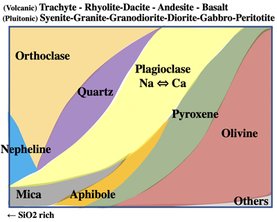
- Igneous rocks differentiated by crystallization:
←Felic rocks --- medium --- magic rocks→ (>Fig.)
- SiO2 ratio: basalt 45-52%, and granite 66% or more.
- Density: basalt 3.0, and granite 2.6
- Granite was formed as a continental mass 4 Ba by crystallization differentiation of basaltic magma.
- Super continents:
- UI Continent 3 Ba, NENA Continent 1.9 Ba, Columbia Super continent 1.8Ba, Rodina Super continent 1Ba, Gondwanaland 500Ma, Pangaea Super continent 300Ma were formed.
- Rocks such as Yemenite are more alkali metal rich rocks against silica content occurred in deeper sub-ducted zone; occurred rarely in Japan.
- Oceanic zone such as Pacific and Atlantic are mostly composed of basalt, while continental zone of granite.
- Sedimentary Rocks:
- Rocks which have settle down and consolidated in water, such as sandstone, shale (grain less than 1/16mm), limestone, etc.
- Rocks such as volcanic ash and pumice which are carried by the wind and consolidated, such as tough and iconoclastic rock.
- Metamorphic Rocks:
- Igneous rocks and sedimentary rocks become metamorphic rocks when their mineral crystals grew or chemically reacted due to pressure and heat; such as gneiss, crystalline schist, marble, etc.
- Rock-forming Minerals:
- which are mostly silicate minerals; basalt is made up such minerals as Olivie, pyroxene, plagiarize, and granite is made up by quarts, mica, and K-feldspar.
- Minerals:
- Inorganically produced natural products, which are solid having a certain range of chemical composition and three-dimensional regular atomic arrangement.
- Ore minerals:
- Metal-based minerals, such as magnetite, copyrighter, galena, etc.
- Gem stone:
- called Gem stones which produces less, do not undergo chemical changes, and are beautiful in color and shape.
- Ancient description of rocks:
- Theosophists (c327BC-287BC; Aristotle's disciple
- to classify the minerals, such indices of color, transparency, brightness, hardness, brittleness and smoothness were used.
- Strabon (c63BC-23AD): described about geography (17 volumes), including volcanoes such as Etna, Vesuvius, etc. Vesuvius volcano erupted on 79/8/24.
- Roman Admiral Prinius (23-79); wrote Natural History (37 volumes) He died during the research of the eruption of Vesuvius.
- Late 18C to early 19C: Origin of rocks:
- Neptunism: Abraham Werner insisted that granite was made first by settled down deposit in the primordial ocean.
- Also advocated the concept of index fossils. Goethe supported this Neptunism.
- Platonism: James Hutton insisted that granite is made deep as a plutonic rock of igneous source. Sedimentation is secondary action.
- Etymology of volcano is Vulcan, the Roman God of fire and blacksmithing.
- Stones and rocks described in the Bible:
- The name of disciple Petros, whose real name is Simon, was give the name of stone.
- The name of Basilica di San Pietro in Vaticano (St. Peter's Basilica); Pietro is Italian name of Petro (Peter)
- History of the Earth:
- The Old Testament: the creation was 4004BC/10/23
- 18C: French naturalist Buffon (1707-88) calculated the cooling time of an heated iron ball, and estimated the earth take 74,832 years to cool down.
- William Thomson (1824-1907); estimated history of the earth was 20M-400M years.
- Stratigraphic Chart (in 2008)
-
Cenozoic
Quaternary 2.588
Holocence 0.0117| Pleistocene
Neogene 23.03
Pliocene 5.33| Miocene
Paleogene 65.5
Oligocene 33.9| Eocene 55.8| Paleocene
Mesozoic
Cretaceous 145.5
Upper 99.6| Lower
Jurassic 199.6
Upp 161,2| Mid 175.6|Low
Triassic 251.0
Upp 228.7| Mid 245.9|Low
Paleozoic
Permian 299.0
Upp 260.4| Mid 270.6|Low
Carboniferous 359.2
Pennsylvanian 318.1| Mississippian
Devonian 416.0
Upp 385.3| Mid 397.5|Low
Silurian 443.7
Pri 418.7|Lud 422.9| Wen 428.2 | Llandovery
Ordovician 488.3
Up 460.9| Mi 471.8|Lo 488.3
Cambrian 542.0
Furo 499| Seri3 510| Seri2 521| Terreneuvian
Pre- Cambrian
Proterozoic 2500
Neo 1000| Meso 1600| Paleo 2500
Archean eon 3800
Neo 2800| Meso 3200| Paleo 3600|Eoarchean 4000
Hadean eon 4600
- Start of Quaternary 2.588 ma (formerly 1.80 ma)
- since then global cooling occurred.
- the advent of human species dates back about 6 ma.
0. 石とは何か:
- 人と石の付き合いは250万年前に遡る。
- 人は、石を掘り出し、刻み運び、積み上げてきた。
- 世界各地の石像建築物は、人と石の格闘の痕跡である。
- これは岩石学視点からの歴史の概観である。
- 岩石は、地球の地殻とマントルを構成し、液体の外核を除く。
- 火成岩、堆積岩、変成岩に分類され。火成岩も最も多い。
- 火山岩分類: 結晶分化作用による
←珪長質岩(酸性岩) ---- 中性岩---苦鉄質岩(塩基性岩)→
(火山)粗面岩・流紋岩・デイサイト・安山岩・玄武岩
(深成)閃長岩・花崗岩・花崗閃緑岩・閃緑岩・斑糲岩・橄欖岩
- SiO2成分は、玄武岩45-52%、花崗岩は66%以上
- 密度は、玄武岩 3.0、花崗岩は2.6
- 花崗岩は、40億年前に玄武岩質マグマの結晶分化作用で大陸地塊として形成された。
- Ul大陸(30億年前)、NENA大陸(19億)、コロンビア超大陸(18億)、Rodinia超大陸(10億)、Gondwana (5億)、Pangea超大陸(3億)が形成された。
- 堆積岩:
- 水中で沈殿・体積して固結した岩石; 砂岩、頁岩、石灰岩など。
- 火山灰や軽石などが風に運ばれ固結した岩石は、凝灰岩や火砕岩
- 変成岩:
- 火成岩や堆積岩に圧力が熱によってその中の鉱物の結晶が成長したり化学反応を起こすことで変成岩となる。片麻岩、結晶片岩、大理石など。
- 造岩鉱物
- 玄武岩を構成するかんらん石、輝石、斜長石、花崗岩を構成する石英、黒雲母、カリ長石など岩石を構成する主として珪酸塩鉱物をいう。
- 鉱物
- 無機的に生成された天然物で、一定範囲の化学組成をもち、三次元的な規則正しい原子配列をもった固体。
- 鉱石鉱物: 金属を主成分とする磁鉄鉱、黄銅鉱、方鉛鉱など
- 宝石: 産出量が少なく、化学変化を起こさず、美しいものをいう。
- 古代の記述
- テオフラストス (c327BC- 287BCアリストテレスの弟子)
- 鉱物の分類指標としえ、色彩、透明度、輝度、硬度、脆さ、滑らかさを用いた。
- ストラボン (c63BC-23AD) 17巻におよぶ地理学; エトナ火山、ヴェスヴィオ火山などを記述。
- 79/8/24に、ヴェスヴィオ火山大噴火
- ローマ提督プリニウス (23-79); 37巻の博物誌発表。ゔエスペラントヴィオ火山調査中に死亡
- 岩石の成因: 18C後半〜19C始め
- 水成論 (Neptunism): アブラハム・ヴェルナー
- 花崗岩は、原始大洋に最初に沈殿した生成
- 示準化石の概念を提唱
- ゲーテも水成論を支持
- 火成論 (Plutonism): ジェームス・ハットン
- 花崗岩は、火成源の深成岩。堆積作用は二次的
- Volcanoの語源は、ローマの火と鍛冶の神ウルカヌス(ヴァルカン)
- 聖書の中の石と岩:
- 弟子ペトロ (Petros)、本名はシモンだが石の名を与えられた。
- サン・ピエトロ大聖堂のピエトロはペトロのイタリア語
- 地球の歴史
- 旧約聖書: 天地創造は、4004BC/10/23
- 18C: 仏博物学者ビュフォン(1707-88) 74,832年 (鉄の玉の冷却時間の計算から)
- ウイリアム・トムソン (1824-1907): 20M〜400M年
- 2008 IUGS 第四紀の始まりが、2.588百万前となった。
- 地質年代; (<左図):
- 第四紀の始まりは、2.588 maとなった。
- その時期から、世界的寒冷化が信仰
- 人類の誕生は、約6 maまだ遡る。
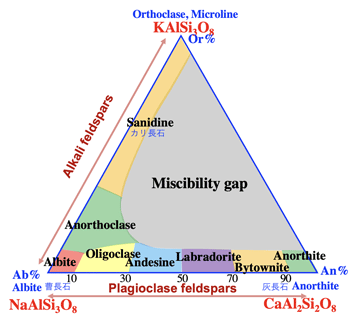
- 長石とは:ほとんどの岩石に含まれるアルミ珪酸塩; 化学組成が連続的に変化する; カリ長石Or、曹長石Ab、灰長石Anの3成分系で、アルカリ長石は主に花崗岩に、斜長石は主に玄武岩に含まれる。+6
>Top 1. Old Continent and its Surrounding Stones:
- Descendants of Vikings:
- 70-50C BC: Danish, Swedish and Norwegian immigrants fro Scandinavia.
- 25C BC: Finish ancestors moved from Ural region of Russia.
- Geology of Scandinavia:
- Mostly covered by the shield of Precambrian era, and Paleozoic layers are distributed around. The west cost of Norway is covered by Caledonian orogen movement in early Paleozoic era, which collided with the shield causing metamorphism.
- the Baltic shield composed of the oldest rocks (gneiss and basaltic rocks in Archean 3100-2500 Ma) are widely distributed in Russian Kora peninsula, Carrelia region, and northernmost Sweden.
- Large iron ore deposits of Kiruna and copper deposit of Falun occurs in the granite zone of Spekoven orogenic belts in norther Finland and Sweden, and Falun red pigment (painted on local houses) is also famous.
- Banded Iron Formation (BIF), where Fe2+ dissolved in seawater was oxidized to Fe3+ forming iron ore deposit.
- Scandinavian hard rocks called Finnish Rapkivi (hornblende biotite granite) is used as building material, featured egg-shaped K-felspar bordered by gray plagioclase, which is also used for stone pillars of St. Perterburg cathedral.
- The vicinity of Oslo is a lift zone (graben zone) where the continental crust and its lower layer were stretched by elongation stress and the surface of the continent is subsided and depressed.
- Larvikite (sysenite containing moonstone) produced in Larvike in southern Oslo shows luster due to separation of Na-rich albite and K-feldspar in the process of crystallization.
- Norway has the longest Sognefjord (204km long; 1308m deep)
- It also produces calcite of carbonatite, made of low-temperature lava.
- Gotland island in eastern Sweden produces lots of Silurian (formerly called Gotland era) index fossils.
- UK - stone country:
- 40C-10C BC: megalithic culture is concentrated mostly in UK and Ireland:
- vertical Menhir, table-shaped Dolmen, and Stone Circle, etc.; which was built during Neolithic period and presumably used as an observatory to observe the movement of the sun, moon and stars.
- rock weight: limestone or marble has specific density of 271, granite 267, and basal 2.97; these are 2.6-3 tons per cubic meter.
- Aberdeen in Scotland is mining hub of North Sea oilfield and is famous for its local granite (called Granite City)
- 11C: Shrewbury Castle was built of red sandstone (color of hematite); such oxidation due to increased oxygen concentration in the atmosphere since Archean (2.3 Ba)
- Chalk layers of late Cretaceous period (microfossils NaCO3 aggregates) are distributed on Dover Strait and Isle of Wight. The chalk contained a dark glassy mass (concretion).
1. 古い大陸とその周辺の石:
- バイキングの末裔
- 70C-50C BC: デンマーク、スェーデン、ノルウェーの人々は北欧から移住
- 25C BC フィンランドの祖先は、ロシアウラル地方から移動
- 北欧の地質;
- 大部分が先カンブリア時代の楯状地。周辺に古生層が分布。ノルウェー西岸は、古生代初期のカレドニア造山運動で、西側でばると楯状地と衝突し、変成作用を起こした。
- バルト楯状地で、最古の岩石 (始生代 3100-2500maの片麻岩や玄武岩)はロシアのコラ半島、カレリア地方、スウェーデン最北部に分布
- フィンランド北部やスェーデンのスペコフェン造山帯の花崗岩帯には、大規模な鉄鉱床 (キルナ(Kiruna)やファールン (Falun)銅鉱床がある。その地域の家に塗られたファールン赤の顔料も有名。
- 縞状鉄鉱床 (Banded Iron Formation, BIF) 海水に溶解していたFe2+が、シアノバクテリアの光合成による酸素でFe3+に酸化されて海中に沈殿して鉱床となった。
- 北欧の硬い石: フィンランドのラパキビ花崗岩 (Rapakivi; Hornblende biotite granite) は建築材料として有名 (卵型のカリ長石を灰色の斜長石が縁どる。) サンクトペテルブルグの大聖堂の石柱に利用
- オスロ近辺は、大陸地殻とその下層が伸長応力によって引き伸ばされ、地表が沈降・陥没したリフト帯 (地溝帯)である。
- オスロ南部ラルビークで産出するラルビカイト (月長石を含む閃長岩); 結晶の過程で、Na主成分の曹長石albiteとK主成分のカリ長石K-fekdsoarの分離による光沢
- ノルウェーには、最長のソグネフィヨルド(204km; 水深1308m)がある。
- カーボナタイトという低温での溶岩性の方解石を産する。
- スェーデン東部のゴトランド島は、シルル紀 (以前はゴトランド紀)の示準化石を多く産出する。
- 石の国英国:
- 40C-10C BC 特に英国やアイルランドには巨石文化が密集している。
- 垂直に立てたメンヒル、テーブル状のドルメン、環状列石など。新石器時代に作られ、おそらく太陽や月の動きを観察する天文台の役割だったと推定される。
- 岩石重量:
石灰石・大理石は比重2.71、花崗岩は2.67、玄武岩は2.97で、1立米では2.6-3トンとなる。
- スコットランドのアバディーン(Aberdeen) 北海油田採掘の拠点。地元産出の花崗岩が有名 (Granite City)
- 11C シュルーズベリー城は、赤色砂岩 (赤鉄鉱の色)で建築された。始生代 (23億年前)以降、大気中の酸素濃度の増加に伴う酸化による。
- ドーヴァー海峡、ワイト島には、後期白亜紀のチョーク層(微化石のNaCO3集合体)が分布。チョーク中には黒っぽいガラス状の塊(コンクリーション)が含まれる。
>Top 2. Tethys Ocean Stones & Mediterranean Coastal Countries:
- Mediterranean countries:
- Tethys Ocean: a gigantic ocean located between northern Laurasia and southern Gondwana of Pangea Supercontinent.
- Until mid-Mesozoic, the Americas were united, and North Pacific did not yet exist.
- At the beginning of Cretaceous period, the rotation of African continent closed the Tethys Ocean and created the Mediterranean Sea.
- Corals grew in the shallow and warm water of the Tethys Ocean, and formed large limestone layers and metamorphosed marble due to collision of the continents.
- 432BC: the Parthenon was built on the Acropolis hill, sits on a late Cretaceous limestone hill. Quarrying was not done due to the sacred place.
- The statue of Venus de Milo was discovered in the island of Milos in the Aegean Sea.
- Lower Jurassic Mable in Toscana region (called Bianco Carrara), which Michelangelo shouted that he wanted to carve the entire rocky mountain. The white marble was used for the statue of David.
- The Roman Colosseum is made of rocks called travertine, which are limestone and marble dissolved and moved by groundwater and repreciptated, and are not consolidated by pressure and are porous. Stalagmites and stalactites are also travertine.
- Limestone, marble and travertine, often used for Greek and Roman architecture, are easy to be processed and contributed to the construction of European civilization. These rocks were formed by the Tethys Ocean and the Alpine orogeny.
- Leonardo da Vinci said, "recognizing past times and state of the earth is flower and fruit of the human spirit."
- Roman Aqueduct:
- the slope is less than 1/200. In the valley, water is passed by the siphon principle, and the aqueduct was built in a gentle sloped places, which could deliver 1 cubic meter per person of water to one million population of Rome.
- Geology of Central Europe:
- the areas of Carpathian mountains and Balkan mountains were formed as an eastern extension of Alpine orogeny.
- granites, metamorphic rocks and sedimentary rocks related to the Paleozoic Caledonina orogeny and Variscan orogeny are widely distributed.
- in the late Cretaceous, global transgressions deposited limestone chalk layers and sandstone of nanoplankton around the Tethys Ocean.
- active volcanic activities associated with separation of the Gondwana continent caused massive emissions of CO2 from internal earth, promoting the greenhouse effect, transgressing about 250 m above current sea level.
- in such environment, the temperature difference between high-latitude and low latitude areas became smaller, causing less seawater circulation and more phytoplankton deposit on the ocean floor; thus 60% of oil was preserved in the Cretaceous formation.
- Buildings in Prague are made of sandstone from late Cretaceous to Tertiary period. (Saint Wenceslas Cathedral)
- Bohemian glass is made of potash glass by mixing high purity silica stone contained in Cretaceous layer, together with beech charcoal as potassium raw material.
- Tebrice hot spring resort in northern part of Czech Republic, is the famous place where Goethe and Beethoven encountered.
- Dresdner Frauenkirche located in Dresden, Germany, was made of late Cretaceous sandstone on the Elbe River bank (Elbe sandstone), which was destroyed by the Dresden airstrike on 1945/2/13. It was rebuilt in 2005 after the unification of Germany, using the original stones as much as possible.
- Egypt:
- Sahara Desert was covered with greenery 7-5K years ago, which became desertified since 3K years ago.
- The Great Rift Valley of Africa extends south from central Ethiopia to Lake Vitoria, Lake Tanganyika, and Lake Malawi via the Red Sea. The Olduvai Gorge in the eastern rift zone is the place where early human fossils were discovered. The rate of division is about 5 mm per year.
- From eastern Egypt to the Arabian Peninsula, late Proterozoic granites and metamorphic rocks are distributed.
- Along the Nile River, Paleozoic and Mesozoic sandstone and limestone constitute the bedrock, on which Paleogene basalt is covered, and Quaternary sand dunes strata spread over it.
- Egyptian stone statue structure:
- Stature of Falcon: made of diorite gneiss from upstream of the Nile.
- Stature of King Menkaure and three others: made of green silt and sandstone between the Nile and the Red Sea.
- Peregrine Falcon Statuette: made of purple dacite dotted with whit patchy feldspars.
- King Khufu's chamber in the Pyramid: made of rosy granite in southern Aswan
- King Khufu's Great Pyramid: 138m high, 230m bottom wide, having 51º50' slope; the limestone contains fossils of large
- Rosetta Stone discovered in the delta of the Nile: is granodiorite. foraminifera (called nummulite)
- Statue of Mendokuhotep II: made of Nubian sandstone widely distributed fro Egypt to Libya.
- Pyramids and Old Kingdom Temples: made of Eocene limestone along the Nile (Mochatam formation of middle Eocene and Murdy formation of late Eocene)
- Sphinx in Giza: created by digging out late Eocene limestone (Murdy formation), featured alternating layers of limestone and marl.
2. テチス海の石と地中海沿岸諸国:
- 地中海沿岸諸国:
- テチス海: パンゲア超大陸の北ローラシアと南ゴンドワナ大陸の間にまたがる海。
- 中生代中頃まで南北アメリカ大陸は合体しており、北太平洋はまだ存在していなかった。
- 白亜紀の始めには、アフリカ大陸の回転によって、テチス海が閉じられ地中海が生まれた。
- テチス海の浅く暖かい海ではサンゴが生育し、それらの体積から石灰岩、その後の大陸の衝突による変成作用で大理石となった。
- パルテノン神殿のあるアクロポリスの丘は、後期白亜紀石灰岩の丘の上にある。神聖な場所として採石は行われなかった。
- エーゲ海に浮かぶミロス島からはミロのヴィーナスが発見された。
- トスカーナ地方の下部ジュラ系大理石(ビアンコ・カーラーラ) ミケランジェロが山全部を彫ってしまいたいと叫んだ。ダビデ像にも利用した白い大理石。
- ローマのコロッセオは、トラバーチン(travertine)でできている。石灰岩や大理石が地下水によって溶解・移動して再沈殿したもので圧密を受けておらず多孔質である。石筍や鍾乳石もトラバーチンである。
- ギリシア・ローマの建築に多用される石灰岩・大理石・トラバーチンは加工しやすくヨーロッパ文明建設に寄与した。これらを生んだのは、テチス海の形成とアルプス造山運動である。
- レオナルド・ダビンチ曰く、"過去の時代と大地の状態を認識することは人間精神の花であり実である。"
- ローマ時代の水道橋:
- 傾斜は1/200以下。谷間ではサイホンの原理で通水し、傾斜が緩い場所に水道橋を建築。1立米/人の水量をローマ100万人に届けた。
- 中欧の地質:
- アルプス造山運動の東の延長としてカルパチア山脈やバルカン山脈が形成された。
- また古生代のカレドニア造山、ヴァリスカン造山運動に関連した花崗岩や変成岩や堆積岩類が分布する。
- 白亜紀後期には、世界規模での海進によってテチス海の周辺部にナノプランクトンによる石灰質のチョーク層や砂岩が堆積した。
- ゴンドワナ大陸の分離に関連した活発な火山活動によって地球内部からのCO2の大量放出が起こり、温室効果を促進し海進よって現在の海水面より約250mも高くなった。
- 高緯度地域と低緯度い地域の温度差が小さくなり、海水の循環が起きにくくなり、植物プランクトンは海洋底に堆積した。石油の60%は白亜紀層に包含されている。
- プラハの建物には、白亜紀後期〜第三期にかけての砂岩を使った建造物おい。(聖ヴァーツラフ大聖堂)
- ボヘミアン・ガラスも、白亜紀砂岩層に含まれる純度の高い珪石にカリウム原料としてブナの木炭を混ぜたカリガラスである。
- チェコ北部の温泉保養地テブリツェでは、ゲーテとベートーヴェンが邂逅したことで有名。
- ドイツのドレスデンの聖母教会 (フラウエンイルヒェ)はエルベ川岸に分布する白亜紀後期のエルベ砂岩で作られていたが、1945/2/13のドレスデン大空爆で破壊された。ドイツ統一後の2005に元の石を極力活かす形で再建された。
- エジプト:
- サハラ砂漠は7-5K年前は緑に覆われた時代だったが、3K年前以降は砂漠化が進行した。
- 紅海を経てエチオピア中央部からヴィトリア湖、タンガニーカ湖マラウィ湖に向けてアフリカ大地溝帯が南下している。東部地溝帯のオルドバイ峡谷は、初期人類の化石が発見された場所である。分裂の速度は5mm/年ほど。
- エジプト東部からアラビア半島にかけて原生代後期の花崗岩や変成岩が分布する。
- ナイル流域には古生代や中生代の砂岩や石灰岩の岩盤の上に古第三紀の玄武岩など、その上に第四紀の砂丘成層が広がっている。
- エジプトの石像構築物:
- ファルコンの像: ナイル川上流の閃緑岩質片麻岩
- メンカウラー王ほか三人像: ナイル川と紅海の間の緑色シルト・砂岩
- ハヤブサの小像: 紫色に白色の斑状長石が点在するデイサイト
- クフ王ピラミッドの玄室: アスワン南部のバラ色花崗岩
- クフ王の大ピラミッドは、高さ138m、底辺230m、勾配51度50分; 大型有孔虫の化石を含む石灰岩(貨幣石)
- ロゼッタ・ストーンは花崗閃緑岩
- メンドクホテプIIの像: エジプトからリビアにかけて広く分布するヌビア砂岩
- ピラミッドや古王朝の神殿: ナイル川沿いの始新世の石灰岩 (始新世中期のモカタム層と後期のマーディ層)
- ギザのスフィンクス: 始新世後期の石灰岩(マーディ層)を掘り抜いて作成された。石灰岩と泥灰岩の互層
>Top 3. Old Asian Continent & Tethys Ocean Stones:
- Tibetan Plateau:
- In mid-Cretaceous period (80 Ma) the Indian sub-continent was separated and moved north from Godwana continent, collided with the Eurasian continent at 55 Ma subsided in from the south; causing the Himalayas rose on southern edge of the Eurasian continent. It is still rising at 1 to several mm per year. Due to this double structure, Tibetan Plateau emerged. (>Fig.)
- Cross Section of the Himalayas:
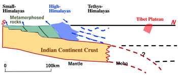
- Thickness of the crust in Tibetan Plateau is 70km, which is twice the average crust thickness. Asian major rivers, Yellow River, Yángtze River, Mekong River, Indus River, and Ganges Rive flow from this plateau.
- The altitude of Sìchuān Basin is about 500m, but it reached 4000m at the eastern end of Tibetan Plateau. Thus Tibetan Plateau rises above Sìchuān Basin and forms active faults such as Lóngménshān Fault in the west of Chéngdū, because the collision faces east near Sìchuān Province.
- The Himalayas rain heavily in the south, and Tibetan Plateau prevents the winter Siberian cold air mass moving south. Thus it causes low atmospheric pressure as heat source in summer, and it cools and become a source of high pressure, resulting monsoon climate in east Asia.
- Mongolian Plateau:
- At western end of the border with Xīnjiāng, there is the Altai Mountains over 4000m, and in the central part of Mongol is the Khangai Mountains over 3000m.
- The Gobi Plain extends near the border with the Inner Mongolia.
- To the north, a lift zone extends along Lake Baikal, which leads to Lake Khuvsgul, the largest lake in Mongolia.
- The area around Mongolia consists of Mongolian Plateau (average 2000 m high) between Angara Shield, which is a part of Eurasian plate, and the north China block. Mongolian plateau consists of Proterozoic to Paleozoic orogenic belts, covered by late Jurassic sedimentary rocks and are a treasure trove of dinosaur fossils.
- Mongolian Plateau has volcanoes and hot springs associated with collision of the Indian continent with Eurasian continent during Eocene period.
- In Inner Mongolia, there is also Bayan Obo (a symbol of natural belief of piled up stones); rare metals are produced in the limestone around this area.
- There are pedestals of turtle-shaped monument, which is made of Amazonite granite.
- Indochina Peninsula:
- In the Tonle Sap River basin, where a tributary of long Mekong River flowing into Tonle Sap Lake, the largest freshwater lake in the tropical region.
- In rainy season, Mekong River flows back into the lake, and in dry season, and equal amount of soil is discharged from the lake; sedimentation of the lake has almost stopped. Sediments in norther part of the lake produce clay minerals originating from Mekong river.
- Angkor Wat Site: was build using Jurassic fine-grained sandstone (yellow to red sandstone, green-blue gray Wacke) and Fe and Al-rich laterite (red clay) distributed in western Cambodia.
- Chinese Geology:
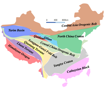
- Rocks from Archean to Quaternary can be seen extensively, which was made from small blocks when Godwana continent merged northward; Archean crystalline schist, gneiss, granite, striped iron ore layer, covered by Paleozoic igneous rocks, limestone sandstone, shale, coal seam, and also Mesozoic igneous rocks and metamorphic rocks due to collisions between continents. (>Fig. above)
- Great Wall:
- Total length 8851 km. stones used for construction are crystalline schist, granite, limestone, and slate from peculiar to the region due to transportation restrictions.
- In the area such as Dūnhuáng, where there is no stones, quicksand and pebbles were tamped with soil or build with bricks. Natural terrain such as cliffs are also used.
- Some walls use natural terrain such as cliffs.
- Loess (Huángtǔ):
- originates from Taklimakan Desert and Gobi Rock Desert in western China.
- The size of yellow sand is 2-5 μm (1/10 of ceder pollen). It flies to a distant place on the westerlies wind.
- Yellow River delta: huge deposits from the Loess Plateau in the middle course of the river.
- Yangtze River delta:
- The water flow area is vast and the amount of water is large, and influence of seasonal changes in water level and tides is also large.
- Thick sediments and deep valleys since the Ice Age (Holocene) can be seen. During the Ice Age, the sea level was 100 m lower than now, so the erosion was very active.
- Since the time of Suí Yáng Dì (569-618), Jīngháng Waterway form Hángzōu to Běijīng has be excavated to improve north-south traffic.
- the largest lake in the Yangtze River delis is Tàihú Late (2338 sq.m), which was believed to be a meteorite pit. There are coesite and stishovite in which quarts was metamorphosed under high pressure.
- Jiāngnán Region:
- Further excavation of the Jīngháng Waterway. Successive governments continued to expand Jīngháng Waterway, which connects Yellow River and Yangtze river.
- Strangely shaped limestones (called Hàihú stone) are placed in the gardens of each city. These are limestones carved by Paleozoic to Mesozoic erosion.
- Sūzhōu Canal and City Gate: slightly red colored Suzhou granite intruded in Cretaceous period, which has many K-felspars and fluorite. In addition, mosaic of blue, white, and light red colored rocks of shale and tuff are used for gardens and passageways.
- Guìlín:
- Spectacular karst landform made of coral-deposited limestone deposited from Devonian to Carboniferous in the warm and shallow water of Tethys Ocean.
- Ferns deposited in shallow waters and lakes inside the land formed coal layer.
3. アジアの古い大陸とテチス海の石:
- チベット高原:
- 白亜紀中頃 (80Ma) インド亜大陸は、ゴンドワナ大陸から分離・北上し、55Maにユーラシア大陸と衝突して南から潜り込み、ユーラシア大陸の南縁部にヒマラヤ山脈が隆起した。現在でも1〜数mm/yで隆起中。この二重構造によりチベット高原が出現した。(>左図)
- チベット高原の地殻の厚さは70kmで、平均地殻の二倍。この高原から黄河、揚子江、メコン川、インダス川、ガンジス川が流れ出ている。
- 四川盆地の標高は500m程度だが、チベット高原東端では4000mに達している。チベット高原は四川盆地の上にのし上がって形になっており、四川省付近では衝突は東向きなので成都西方に龍門山断層など活断層を生じている。
- ヒマラヤは、南部に大量の雨を降らせ、チベット高原は冬のシベリア寒気団の南下を防いでいる。夏には熱源となり低気圧を、冬には冷却して高気圧の発生源となり、東アジアのモンスーン気候をもたらす。
- モンゴル高原:
- 西端の新疆との国境には、4000mを越すアルタイ山脈があり、国の中央部には3000mを越すハンガイ山脈がある。
- 内モンゴルとの国境付近はゴビ平原が広がる。
- 北方は、バイカル湖に沿ったリフト帯が延びており、モンゴル最大のフブスグル湖につながる。
- モンゴル周辺は、ユーラシアプレートの一部であるアンガラ楯状地と北中国地塊との間のモンゴル台地から成り、平均標高は2000mに達する。モンゴル台地は原生代〜古生代の造山帯から成る。またこれらをジュラ紀後期の堆積岩が覆っており、恐竜化石の宝庫である。
- モンゴル高原には、始新世にインド大陸がユーラシア大陸と衝突に関連した火山や温泉がある。
- また内モンゴルのバヤン・オボ (石を積み重ねた自然信仰)は石灰岩中にレアメタルの産する。
- 亀趺(きふ)は、亀の形の碑の台座であり、アマゾナイト花崗岩で造られている。
- インドシナ半島:
- 長大なメコン川の支流であるトンレサップ川流域に、熱帯地域最大の淡水湖トンレサップ湖がある。
- 雨季にはメコン川が逆流して湖に流入し、乾季には湖から等量の土砂が排出され、湖の堆積作用はほぼ停止している。湖北部の堆積物は、メコン川を起源とする粘土鉱物を産出する。
- アンコール遺跡: カンボジア西部に分布するジュラ紀の細粒砂岩(黄色〜赤色砂岩、緑青グレイワッケ)、とFe・Alを豊富なラテライト(紅土岩)を利用して建造された。
- 中国の地質:
- ゴンドワナ大陸からの小ブロックが北上合体した始生代〜第四紀までの岩石が広範囲に見られる。始生代の結晶片岩や片麻岩、花崗岩、縞状鉄鉱層、原生代の火成岩、古生代以降の石灰岩、砂岩、頁岩、石炭層や、大陸同士の衝突による変成岩や中生代の火成岩などが複雑に分布している。
- 万里の長城: 総延長8851km
- 石材は、運送の制約のため、結晶片岩、花崗岩、石灰岩、粘板岩などその地域特有の岩石を利用している。
- 石材がない敦煌などでは、流砂、小石を土で突き固めて、あるいは煉瓦で建造した。
- 崖など天然の地形を利用したものもある。
- 黄土:
- 中国西部のタクラマカン砂漠やゴビ岩石砂漠が起源である。
- 黄砂の大きさは2-5μm (杉花粉の1/10)。偏西風に乗って遠方まで飛来する。
- 黄河デルタ: 中流の黄土高原からの巨大な堆積物
- 長江デルタ:
- 流水域が広大で流水量が多く、また水位の季節変化と潮汐の影響が大きい。
- 氷河期以降(完新世)の厚い堆積物や深い谷が見られる。氷河期には海水面が現在より100mも低かったので、浸食作用が活発だった。
- 随の煬帝の時代以降、杭州から北京までの2500kmに及ぶ京杭大運河が開削され南北の交通が改善した。
- 長江デルタの最大の湖は太湖 (2338平米)だが、隕石孔であると報告された。石英が高圧変成したコーサイトやスティショバイトが存在する。
- 江南地方:
- 京杭大運河の開削。黄河と長江をつなぐ南北の大運河を歴代政権が建造してきた。
- 各都市の庭園には、奇妙な形の石灰岩(太湖石)を配置している。これらは古生代〜中生代の侵食によって削られた石灰岩である。
- 蘇州の運河・城門: 白亜紀に貫入したやや赤色の蘇州花崗岩でカリ長石や蛍石が多い。さらに庭園や通路には、頁岩や凝灰岩と組み合わせた青、白、薄赤のモザイク状で利用される。
- 桂林:
- デボン紀〜石炭紀に、テチス海の暖かく浅い海にサンゴなどが堆積した石灰岩が侵食を受けたカルスト地形による奇観を呈している。
- 陸地内部の浅い海や湖のシダ類は石炭を形成した。
- 翡翠輝石:
- 新疆ホータン付近に産出する角閃石の針状結晶が集合した軟玉(ネフライト)が、中国の玉である。翡翠輝石より硬度が低く細工しやすい。
- 翡翠輝石は、低温高圧で形成される。海洋地殻が上部マントルの一部とともに沈み込む所は、低温高圧の変成作用を受け、その後の地殻変動で地表に現れたオフィオライト地塊は発見される。(糸魚川の石炭紀の翡翠輝石)
>Top 4. New Orogeny Belt Stones:
- Supercontinent Pangea 300Ma, then formed Ththys Ocean 200Ma

- At the end of Carboniferous period (300 Ma), there was the supercontinent Pangea, composed of Laurasia in the north and Godwana in the south, and made Tethys Ocean in-between. (>Fig. above) Later, the Indian subcontinent, which moved north around 80 Ma, formed the Himalayas by collision with Eurasia continent.
- From southern Europe to Turkey, a part of Tethys Ocean closed to be Mediterranean Sea, forming the Alps.
- In the Americas continents, a subduction zone was formed on those wester edge, and large-scale granite intrusions occurred in early Cretaceous, forming foundations of the Sierra Nevada and Andes.
- During Cenozoic era, subduction of ocean floor became active at the continental boundary of the Pacific Rim; the Japanese Archipelago became an island arc separated from Asian continent, and Sea of Japan was formed, where volcanic activity due to collisions and subduction is active in the Pacific coast and Mediterranean coast.
- Anatorian Landmass:
- Mt. Ararat (5165m) on the border with Iran is a typical stratovolcano. (Old Testament describes that Noah's Ark was washed ashore).
- Anatolian Peninsula was part of Eurasian and African continents during Mesozoic era. It was then compressed by northward movement of Arabian plate which collided with Eurasian plate along the North Anatolian Fault. Southern part borders African Plate by a subduction zone which tilted north toward Cyprus, Crete, and western Greece.
- In 1999, big earthquakes (M7.4 and M7.2) struck along North Anatolian Fault, causing 18K casualties.
- There are many hot springs in Anatolia region, and recrystallized travertine is famous which melted from limestone base into hot springs, forming unique landscape like Pamukkale rice terraces.
- Roman old city Polisher structures utilized ivory-colored striped travertine called Phrygian marble.
- Four seasons of Cappadocia consist of columnar eroded tuff, and the mushroom-shaped head is the part where pumice is welded and hardened.
- In addition, underground pits of Christians who escaped persecution from around 4C look like doves' net-shaped cave houses where tuff was excavated. (similar to Yáotòng in Yellow Rivers region)
- Turquoise (originally from Persia): which is a phosphate mineral containing Cu, Fe, and AL which changes to sky blue to green in proportion to the ratio of Cu and Fe.
- Lapis Lazuli (<L. lapis=stone) is a deep-blue metamorphic rock; main component is lazurite, a blue felspathoid Na, Ca containing silicate mineral, and used as a pigment for ultramarine.
- Marble around Marmara Sea: (<G. marmaros =marble) used for stone materials of Topkapu Palace and Blue Mosque.
- Italian Peninsula:
- It is a volcanic zone where limestone deposited in Tethys Ocean is widely distributed. Sicily and Lipari are still active volcanic islands.
- Vesuvius Volcano: erupted around 13:00 on 79/8/24, and a large amount of pumice and ash hardened The eruption lasted a couple of days, completely covering Pompeii town of 20K habitants, and was buried and preserved under ground until it was rediscovered in 1748.
- Gaius Plinius Secundus, Roman politician & naturalist, landed near the foot of Vesuvius Volcano to rescue and record the eruption, but was killed by the hot air. His nephew remained in a shelter and told historian Tacitus what happed during that time.
- Lava flows from the volcanoes in Central Italy, including Vesuvius is gray basaltic lava, containing Ka but poor in silica.
- The first explosion of Vesuvius was pumice and ash hardening, but the next day a pyroclastic flow broke out and buried completely the town.
- American Continent:
- Precambrian shield is widely distributed from central part of North America to South America, which is surrounded by Paleozoic to Mesozoic layers.
- Mesozoic to Cenozoic fold mountains are distributed along the Pacific side, and earthquakes are also active.
- Rocky Mountains composed of Precambrian rocks stretch in Midwest of North America, and Colorado Plateau stretches to the south.
- Sierra Nevada Mountains composed of Mesozoic granite rocks, stretch north-south in eastern California. From there, Baesnan Rane, a rift zone due to crustal elongation, continues to Colorado Plateau up to Mexico.
- Volcanic zone of Rio Grande Rift region develops on the eastern side of Colorado Plateau.
- In mid-Pleistocene epoch, huge volcanic activity erupted Banderia tuff, covered the old topography and formed giant Toledo caldera.
- After 300K years, pyroclastic flow erupted again, creating a vast pyroclastic flow plateau, forming a bias caldera and a group of rhyolite domes on the central uplift area.
- In that tuff field, there remains the Benderia ruins of indigenous Pueblo Indians. To the northeast of this site, sandstone and shale of late Cretaceous period are characterized by a table-like topography (called mesa), and also there remains of indigenous dwellings on the cliffs.
- Japanese Stone Culture:
- Japanese Geology: (>Fig.)
- There are no magnificent stone stature buildings like those in Europe because of the danger of frequent earthquakes.
- Geological structure of Japanese archipelago consist of rocks from Cretaceous to Pleogene period, except a small amount of Paleozoic plutonic and metamorphic rocks. The boundary between northeaster Japan and southwestern Japan is Tanagura Tectonic Line.
- Median Technonic Line (MTL): A huge fault cutting across southweaster Japan from Kyushu to Kanto.accretionary deposits in Jurassic period caused giant strike-slip faults along the boundary with the Pacific Pate in Cretaceous period.
- Ryoke metamorphic belt which is in contact with north side of MTL (inner belt) was made in Cretaceous period by high-temperature, and low-pressure type metamorphism associated with ascent of magma.
- On the other hand, Sanbagawa metamorphic belt adjacent to south of MTL (outer zone) is low-temperatue and high-pressure motamorphic rock mass associated with subduction of the Philippine Sea Plate.
- During paleolithic to neolithic (Jomon period), chipped and ground stone tools were made from siliceous shaled, silicified tuff, fine-grained andeside (such as sanukite), obsidian, and chalcedony.
- Metallic iron was found in ancient sites, which contains about 7% Ni, indicating use of meteoric iron. (Smelting of iron was discovere in Hittites of Anatolian Peninsula in 15C BC.)
- On the other hand, Au, Pt, and Cu were were used from earlier times becasu they occurred as elements or alloys.
- Granites are classified into magnetite-rich granites and ilmenite-rich granites. Sanyo area produced ilmenite-rich granite, and Sanin ares magnetite-rich grantite. Weathered mountain iron sand depsite were distribute in Chugoku region; which became major supplier of agricultural equipent and weapons made by iron by uninque way of Tatara iron production method.
- During Carboniferous period, Kitakami ancient land was a part of the South China. Between Paled-Tethys Ocean and Paleo-Pacific, a subduction zone was formed from Paleozoic scribes, and serpentinite, distributing gabbro, and basalt in the region (including Mt. Hayachine 1914m, the peak).
- In Tohoku region, there are Cu, Fe deposits and Au, W depositel in Kitakami Mountains area, and Cu, Pb, and Zn deposits (called Kuroko) in the Gree Tuff area made by Neogeen volcanic activity on Japan Sea side. Also placer Au (dust Au) in Wakuya area in Miyagi Pefecture is famous and used for Todaiji Great Buddha. It was a tresure trove of metal resources such as Iwate Koganetsubo gold mine (used for Hiraizumi Gold Temple). But all mines in the region were closed now.
- Most of jadeite was found at variouos archaelogical sites nationwide is from Itoigawa Kotaki area alodn Itoigawa-Shizuoka Fault Line, which occured in subduction area of the oceanic crust and a part of upper mantle during Carboniferous period at lower temperature and high pressue conditions.
4. 新しい活動帯の石:
- パンゲア超大陸:
- 石炭紀末(300Ma)には北のローラシアと南のゴンドワナ大陸が合体したパンゲア超大陸が存在し、両大陸の間にテーティス海が存在した。(<左図)
- 80Maに北上したインド大陸は、ユーラシアと衝突したヒマラヤ山脈を形成した。
- 南欧からトルコにかけては、テティス海の一部が閉じて地中海となり、アルプス山脈が形成された。
- 南北アメリカ大陸では、西縁に沈み込み帯が形成され、白亜紀初期に大規模な花崗岩の貫入があり、シエラネバダ山脈やアンデス山脈の土台が形成された。
- 新生代には、環太平洋地域では、海洋底の沈み込みが大陸境界部で活発化し、流動性のアセノスフェアの上昇貫入が起こり、日本列島はアジア大陸から分離した島弧となり日本海が形成された。太平洋沿岸地域や地中海沿岸地域では衝突や沈み込みによる火山活動が活発である。
- アナトリア地塊:
- イランとの境界のアララト山(5165m)は代表的な成層火山である。(ノアの方舟が漂着したとされる旧約聖書の記述)
- アナトリア半島は、中生代にはユーラシア大陸とアフリカ大陸との一部だった。その後アラビアプレートの北上によって圧縮を受け、北アナトリア断層によってユーラシアプレートと接する。南部は、キプロス島、クレタ島、ギリシア西部にかけて北に傾いた沈み込み帯によってアフリカプレートと接している。
- 1999には、北アナトリア断層に沿ってM7.4とM7.2の大地震が発生し、18K人が犠牲となった。
- アナトリア地方では温泉が多く、基盤の石灰岩から温泉に溶けて再結晶した石灰華(トラバーチン)が有名(パムッカレの棚田)
- ローマ時代のヒエラポリスの建造物は、フリギア大理石と呼ばれる象牙色の縞状トラバーチンを利用している。
- カッパドキアの四季は、柱状に侵食された凝灰岩から成り、きのこ状の頭部は軽石が溶結硬化した部分である。
- また、4C頃から迫害を逃れ住んだキリスト教徒の地下壕も凝灰岩を掘削した'鳩の巣'状の洞窟住宅である。(中国黄河地帯の窑洞ヤオトンに相当)
- トルコ石(元はペルシャ産): Cu, Fe, Alを含んだリン酸性塩鉱物で、CuとFeの比率で空色と緑色に変化する。
- 瑠璃は、ラズライトと呼ばれるNa, Caを含む珪酸塩鉱物で、ウルトラマリンの顔料として使用された。
- マルマラ海周辺の大理石: (G.marmaros =marble) トプカプ宮殿やブルーモスクの石材に利用された。
- イタリア半島
- テチス海で堆積した石灰岩が広く分布する火山地帯である。シチリア島やリパリ諸島は活発な火山島である。
- ヴェスヴィオ火山:79/8/24 13:00頃噴火し、大量の軽石と火山灰が硬化した。
- 噴火は2-3日続き、66ha、人口2万人のポンペイの町は完全に覆われてしまい、1748年に再発見されるまで地中に保存された。
- 大プリニウスは、救援と噴火の記録のため山麓近くに上陸したが熱風のため殉職した。その甥の小プリニウスは、避難所にいて、その間の経緯を歴史家タキトゥスに伝えた。
- ヴェスヴィオ火山など中部イタリアの火山はシリカの乏しいもののKaを含む灰色玄武岩質溶岩が流れた。
- 爆発最初は、軽石と火山灰硬化だったが翌日火砕流が発生し、町は完全に破壊された。
- アメリカ大陸:
- 北アメリカ中東部から南アメリカにかけて先カンブリア時代の楯状地があり、それを取り囲んで古生代〜中生代の地層が広がる。
- 太平洋側には、中生代〜新生代の褶曲山脈が分布し、地震活動も活発である。
- 北米中西部には、先カンブリア時代の岩石からなるロッキー山脈が連なり、その南部にコロラド高原が広がる。
- 中生代の花崗岩類からなるシエラネバダ山脈がCA州東部に南北に伸びている。そこからコロラド高原の間に、メキシコにむけて地殻の伸長によるリフト帯であるベーズナンドレンジが続く。
- コロラド高原の東側には、リオ・グランデリフトの火山地帯が発達する。
- 更新世中頃、バンデリア凝灰岩を噴出する巨大な火山活動が起こり、古い地形を覆い尽くし、巨大なトレドカルデラを形成した。
- さらに30万年後、再び火砕流を噴出し、広大な火砕流台地を生じ、バイアスカルデラができ、その中央の隆起部には流紋岩のドーム群ができた。
- その凝灰岩地帯には、先住民のプエブロインディアンのバンデリア遺跡がある。この遺跡の北東には白亜紀後期の砂岩・頁岩がテーブル状の地形(メサ)が特徴であり、崖には先住民の住居跡がある。
- 日本の石文化:
- 日本の地質:
- 地震の危険があり、欧州のような壮大な石像建築は見られない。
- 日本列島の地質構造は、古生代の深成岩類は小規模あるが、大部分は白亜紀〜古第三紀の構造の上に成り立っている。東北日本と西南日本の境界は棚倉構造線である。
- 中央構造線(MTL): 西南日本を九州東部から関東へ横断する巨大な断層。ジュラ紀に大陸縁の海溝で付加された付加体が、白亜紀に太平洋プレートとの境に沿って巨大な横ずれ断層を生じた。
- 白亜紀に変成を受けた領家変成帯は、MTLの北側(内帯)に接し、マグマの上昇に伴う高温低圧型変成岩体である。一方、MTL外帯に接する三波川変成帯は、フィリピン海プレートの沈み込みに伴う低温高圧型変成岩体である。
- 旧石器時代〜縄文時代は、珪質頁岩、珪化凝灰岩、サヌカイト(細粒安山岩)や黒曜石や玉髄の打製石器や磨製石器が作られた。
- 古代の遺跡からの金属鉄にはNi が約7%含まれており、隕鉄の利用は明らか。(鉄の精錬は15C BCのアナトリア半島のヒッタイトとされる)
- 一方で、Au, Pt, Cuは単体や合金として産するので早くから使われた。
- 花崗岩類には、磁鉄鉱系花崗岩とチタン鉄鉱系花崗岩とがある。山陽地域にはチタン鉄鉱系が、また山陰地域には磁鉄鉱系花崗岩が産出する。これが風化して山砂鉄鉱床が分布し、中国地方は、たたら製鉄による農機具や武器の供給地となった。
- 石炭紀には、北上古陸は、現在の南中国に位置していた。古テチス海と古太平洋との間には、古生代書記からの沈み込み帯が形成され、その頃形成された早池峰山(1914m)を構成している蛇紋岩や斑糲岩、玄武岩が分布する。
- 東北地方には、北上山地の銅鉄鉱床や金タングステン鉱床、日本海側のグリーンタフ地域(新第三紀の火山活動)の銅鉛亜鉛の黒鉱鉱床、宮城県涌谷の砂金(東大寺大仏)、岩手金の黄金坪金鉱山(平泉金色堂)など金属資源の宝庫であった。現在はすべて閉山。
- 全国の遺跡で見つかるヒスイ輝石(低温高圧で石炭紀に海洋地殻と上部マントルの一部の沈み込みによる) は、ほとんどが糸魚川小瀧産のものである。
>Top 5. Meteorites & Stones from inside of the Earth:
- Meteorites:
- are classified 1) iron meteorite, Fe/Ni alloys; 2) stony iron meteorites, half Fe/Ni alloys and half silicate minerals; and 3) stony meteorites mostly silicate minerals.
- Falling meteorites about about 1K-10K per year. Falling speed is 10-30km/s. 84% of meteorites are chondrites.
- The age of solar system is calculated by half-lives of radioactive isotopes in meteorite. (U-Pb, Rb-Sr, Nd-Sm)
- There are about 170 craters on the earth. Barriger Crater in Arizona fell 50K years ago, creating 1.km wide and 145m deep crater, where coesite and stishovite formed under high pressure were discovered.
- Sudbury deposit (60km long, 25kim wide) in Canada near the Great Lakes is a huge Ni/Cu deposit. According to recent research, it was also formed by a meteorite impact with 12km diameter during Proterozoic Era at 1.85 Ba.
- Obsidian: is volcanic glass formed when lava extruded from a volcano cools rapidly crystallized; commonly found in the margins of ryholitic lava flows (SiO2 contained 70-80%).
- 1980: Mass extinction:
- Walter Alvarez's Hypothesis:
- Ir concentrates at CT boundary (0.65 Ma) 30 times higher than above and below layers. In addition, minerals formed under high pressure are found, and also many traces of a large tsunami marked the boundary between Mesozoic and Cenozoic epochs.
- At Paleozoic PT boundary (252 Ma9, 90% of organisms such as spindles and brachiopods became extinct. No evidence of Ir enrichment, presence of high-pressured minerals, or traces of large tsunami has been identified at this boundary. Probably large eruptions due to huge plumes, causing large release of CH4 and CO2 resulting destruction of biota due to environmental changes such as hypoxia condition of the deep sea floor.
- Xenoliths:
- Rocks brought to the surface by lava or tuff entrapment during magma ascent, or eruption. Peridot rocks derived from mantle contain a small amount of Ni, giving them a yellow-green color.
- Diamond has a hardness of 10, high thermal conductivity, small coefficient of thermal expansion, and strong acid resistance. Kimberlites are found in old shields such as South Africa, Australia, and the Americas, where explosive eruptions of 150km or more were rapidly lifted to the ground without metastasis, and its transition speed is overwhelmingly slow, so it is stable.
5. 隕石と地球深部からの石:
- 隕石:
- 1) 隕鉄、Fe/Ni合金、2) 石鉄隕石、Fe/Ni合金と珪酸塩鉱物半々、3) 石質隕石、ほとんど珪酸塩鉱物。1mm前後のコンドリュール(球粒)を含むコンドライトとそれを含まないエイコンドライトがある。
- 落下する隕石は、年1K〜10K程度。隕石の84%はコントライト。落下速度は約10-30km/s
- 太陽系の年齢も、隕石中の放射性同位体の半減期で年代測定をする。(U〜Pb、 Rb〜Sr、Nd〜Sm)
- クレーターは、地球上に約170個ある。アリゾナ州のバリンジャー・クレーターは、5万年前に落下し、直径1.3km、深さ145mの隕石孔が生じた。高圧でできるコーサイトやスティショバイトも発見されている。
- 五大湖近くのサッドベリー鉱床 (長さ60km、幅25km)は、巨大なNi/Cu鉱床である。これも最近の研究では、1.85 Baの原生代に直径12kmお隕石衝突によって形成されたとされる。
- 黒曜石: 流紋岩質マグマが急冷することでほぼガラス質の火山岩。SiO2 70-80%を含む。
- 1980: 大量絶滅:
- Walter Alvarezの仮説: CT境界 (0.65 Ma)のイリジウム濃度が上下層に比べて30倍も高い。その他高圧で生成した鉱物の発見や大津波の跡などで、0.66 Maに直径10km (時速 80K km/h)の隕石衝突による転変地異が、中生代と新生代の境となった。
- 古生代のPT境界 (252 Ma)では、紡錘虫や腕足類など生物の90%が絶滅した。この境界では、イリジウム濃集、高圧鉱物の存在、大津波の証拠は鑑定していない。巨大プリュームによる大噴火、これによるメタンやCO2の放出、深海底の低酸素状態など環境変化による生物相の滅亡とされる。
- 捕獲岩 (ゼノリス):
- 溶岩や凝灰岩に取り込まれて地上に運ばれた岩石である。
- 橄欖岩(ペリドット)のMgとFeの比は10:1位で、マントルに由来する橄欖岩には微量のNiが含まれ黄緑色を呈するが、Fe文が増えると濃緑色から黒色になる。
- ダイヤモンド(金剛石)は、硬度10、高い熱伝導率、小さい熱膨張係数、強い耐酸性が特徴。
- キンバーライトは、南ア、豪州、アメリカ大陸など古い楯状地で、150km以上の爆発的噴火に伴って地上に急激に持ち上げられ転移が起こらず見つかる。常温で安定するには2-3万気圧が必要だが、転移速度が圧倒的に小さいので安定的である。
Comment
- History begins in details from the time it was written on paper, but in reality the history recorded on stone is much much longer. Stone and history must be described by such two-way specialists.
- However, the problem is that historians do not know much about stones and petrologists are not familiar with human history.
- In fact, both petrology and history have common features in the sense that they study the events according to the time axis. It is also similar that the target of earth and society are complicated and each unique names (nomenclature) must be remembered.
- This book is unique written by a petrologist who travels the world and focuses on the relationship between stone and history.
- 歴史は、紙に書かれた時代から本格的に始まるが、実は石に記録された歴史の方が遥かに長い。石と歴史とは、それぞれをよく知る者が記述していかなければならない。
- しかしながら歴史学者は石のことをあまり知らないし、岩石学者は人間の歴史に詳しくないのが問題である。
- 実は、岩石学も歴史学も時間軸を意識するという意味で共通性がある。また対象である地球や社会が複雑であることと、個々の名称を個別に覚えなければならない点でもよく似ている。
- 本書は、岩石学者が、世界を旅しながら、石と歴史の関わりに着目したユニークな本である。
$\frac{1}{2}$ |
Stone and Human History
|
Cat: SCI |
Satoshi Kanisawa (蟹沢聡史) |
22731u |
Title |
Stone and Human History |
石と人間の歴史 |
|---|---|---|
Index |
Python Sympy Code |
Remarks |
||||||||||||||||||||||||||||||||||
>Top 0. What is stones?:
|
0. 石とは何か:
|
>Top 1. Old Continent and its Surrounding Stones:
|
1. 古い大陸とその周辺の石:
|
>Top 2. Tethys Ocean Stones & Mediterranean Coastal Countries:
|
2. テチス海の石と地中海沿岸諸国:
|
>Top 3. Old Asian Continent & Tethys Ocean Stones:
|
3. アジアの古い大陸とテチス海の石:
|
>Top 4. New Orogeny Belt Stones:
|
4. 新しい活動帯の石:
|
>Top 5. Meteorites & Stones from inside of the Earth:
|
5. 隕石と地球深部からの石:
|
Comment |
|
|